Blood Basin on I-17: The Arizona Exit Name Steeped in History and Mystery
Hidden within the rugged highlands of Arizona, just off Interstate 17, lies an exit that bears a name both vivid and chilling—Blood Basin. To the casual traveler, it may evoke little more than curiosity or a shudder at the stark imagery. But behind this ominous name is a story soaked in conflict, survival, and cultural collision—one that unfolds across the harsh landscapes and echoes the struggles of the Native Apache people, early settlers, and soldiers who once clashed fiercely in this unforgiving terrain. From dawn raids in canyon ravines to whispered local legends, the story behind Blood Basin is layered with history, myth, and a haunting legacy that offers a glimpse into a turbulent chapter of Arizona’s frontier past.
The Geography of Blood Basin: Nature’s Natural Fortress
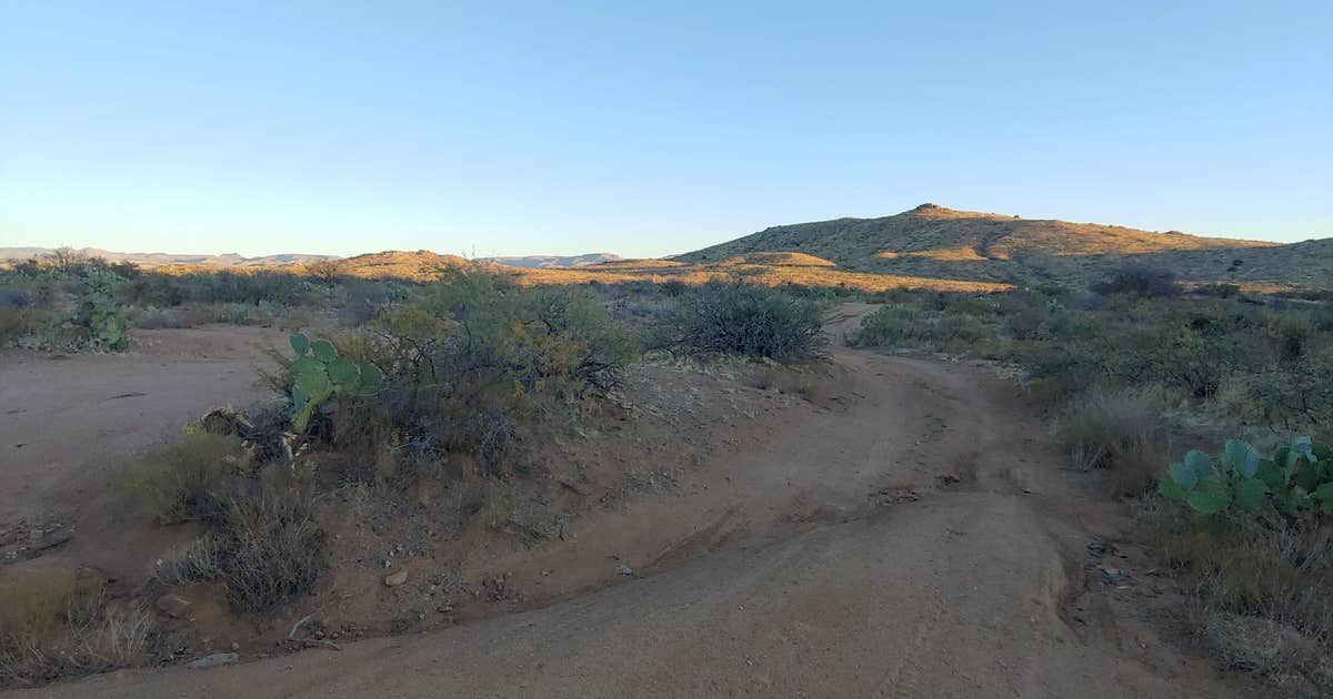
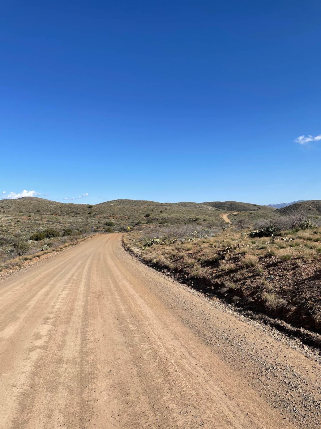
Situated roughly 60 miles north of Phoenix along the twisting paths near Yavapai County, Blood Basin marks the threshold where Arizona’s mountainous highlands merge with the Verde River Canyons. The terrain is a rugged mosaic of steep ridges, deep canyons, and distinctive red rock formations whose rusty hues seem to bleed into the earth itself—perhaps the first visual clue to the name’s stark imagery.
The road itself, accessible from the Blood Basin exit off I-17, winds through about 30 miles of wild country, connecting a string of small towns like Mayer, Bumblebee, and the near-abandoned Crown King. This stretch exists not merely as a route for transit but as a historic pathway that has witnessed centuries of human drama, survival, and conflict. The basin’s natural features created a strategic advantage for those familiar with the land, setting the stage for a fateful battle that would give the area its name.
Arizona Territory in the 19th Century: A Land of Turmoil
To understand Blood Basin’s significance, one must grasp the broader context of 19th-century Arizona, a landscape marked by frontier conflict and cultural upheaval. The Arizona Territory was home to numerous Indigenous tribes, including the Apache, Yavapai, and Tonto-Apache. These Native peoples had thrived for centuries, adapting to this harsh land until the expanding footprint of settlers and military forces sparked violent confrontations.
The word “Arizona” itself is believed to derive from a Pima term meaning “little spring” or possibly “enemy,” reflecting the long-standing clashes between Indigenous inhabitants and newcomers. Tensions in this period were inflamed by competition over land, resources, and survival, making Arizona one of the most conflicted regions in the American West.
The Battle of Turret Peak: Blood Basin’s Defining Moment
The name “Blood Basin” is inextricably tied to a grim chapter of Arizona’s Apache Wars—the Battle of Turret Peak in August 1873. This battle was a pivotal U.S. Army campaign to suppress Apache resistance in the region, led by the renowned General George Crook. At the time, Apache raiders had intensified attacks on settlers, especially around the Hassayampa River near Wickenburg, prompting military response.
Crook’s forces, including scouts like the legendary Al Sieber and the enigmatic Apache Kid, followed tracks leading to a Tonto-Apache base hidden in the steep canyons of what became known as Bloody Basin. In a meticulously planned predawn assault, U.S. troops surrounded the camp, catching the Apache warriors by surprise.
The ensuing battle was fierce and swift. Many Apache men were killed or captured, women and children taken captive, while those who survived faced forced relocation to reservations such as San Carlos. The violent clash left the basin littered with the fallen and the wounded, cementing the area’s grim moniker—a basin soaked with blood, symbolizing the high human cost of the conflict.
The Apache and the Aftermath: Cultural Reverberations
The Battle of Turret Peak was more than a military victory—it was a devastating blow to the Tonto-Apache people, fracturing their way of life and hastening their confinement to reservations. The forced removal and loss of freedom left enduring scars on Apache communities that resonate even today.
Despite this, Apache culture and identity endured, with stories and memories passing orally through generations. The land itself remains sacred, and sites near Blood Basin are reportedly ancient burial grounds and historic places of significance. However, many physical traces such as arrowheads, pottery fragments, and other artifacts have, over time, been disturbed or removed, often illegally despite protections, threatening the tangible preservation of this history.
Local Legends Beyond the Battle
While the Battle of Turret Peak provides the most accepted explanation for the name “Blood Basin,” local lore adds layers of folklore. Some tales speak of ranchers shedding blood to protect their grazing lands from sheep—an echo of territorial disputes between cattlemen and shepherds in the late 19th and early 20th centuries. Another story recounts a tragic accident in the 1940s where sheep reportedly fell from a bridge, staining the rocks red and inspiring another version of the name’s origin.
These stories, while captivating, often blur fact and fiction. Yet they contribute to a cultural tapestry that keeps the name and its stories alive for locals and visitors alike.
Preserving History and Wilderness
Today, Blood Basin is more than a historical footnote; it is part of a wilderness area and outdoor recreation hub where hikers, hunters, and history enthusiasts explore the same wild lands once fought over in deadly conflict. Efforts to protect the area seek to balance access with preservation—honoring Indigenous heritage while offering appreciation of Arizona’s natural beauty.
Efforts include limiting off-road vehicle use to prevent damage to sensitive archaeological sites and encouraging respectful visitation. The legacy of Blood Basin lives not only in textbooks but through the living landscape that continues to shape the identity and memory of the region.
Blood Basin’s Modern Significance
The Blood Basin exit on I-17 serves as both a literal and symbolic gateway to the past. For many travelers, it is a name that stands out—a stark reminder of Arizona’s tumultuous history. For historians and Indigenous communities, it is a sacred story of conflict, survival, and legacy. And for adventurers, it is a portal into some of the most rugged and beautiful wilderness Arizona offers.
The basin’s story, forged in bloodshed and endurance, invites reflection on the cost of conquest and the resilience of human spirit amid the wild, timeless landscape. It is a place where history is palpably etched into the land, waiting for those who seek to uncover its truths and honor its past.
—–
Imagery
Here are some good image suggestions tied to the article about Blood Basin and its history, which would effectively complement the content and engage readers visually:
1. Blood Basin Arizona Landscape
Scenic views of the rugged red rock formations, steep ridges, and canyon terrain that define the natural geography of Blood Basin. These images highlight the landscape’s raw beauty and hint at why it’s such a dramatic setting for history.
Source: wilderness and hiking photos around Bloody Basin near I-17 and Yavapai County.[surgent+2](https://www.surgent.net/highpoints/az/hikes/bloodybasin.html)
2. Battle of Turret Peak Historical Context
Illustrations or historical artworks depicting the 1873 Battle of Turret Peak that gave Blood Basin its name. These could include period drawings of soldiers and Apache, maps of troop movements, or photographs of key figures like General Crook or Apache scouts.
Source: Historical overviews and battle descriptions with visuals from archives or museum collections.[cornerstone-environmental+2](https://www.cornerstone-environmental.com/publications/item/bloody-basin-and-the-battle-of-turret-peak)
3. Apache People and Culture
Photos or artistic depictions representing the Apache people, their traditional clothing, and cultural heritage to give readers a human connection with those involved in the historical conflicts. This would emphasize the Indigenous perspective important for the article’s depth.
Source: Images and descriptions from Apache tribal history and museums.[wikipedia+2](https://en.wikipedia.org/wiki/Apache)
4. Bloody Basin Road and Surrounding Area Today
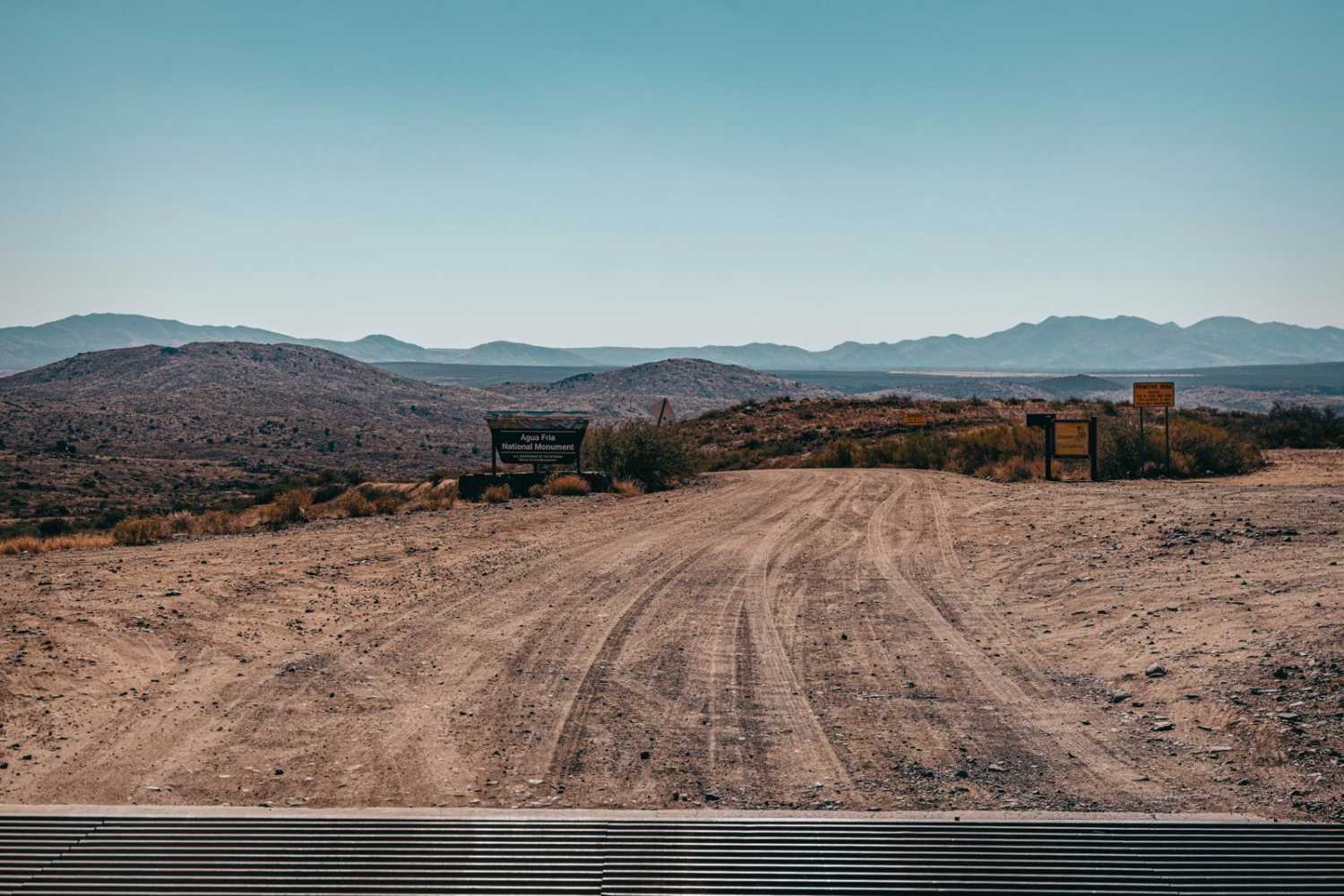
Recent photos of the Bloody Basin Road off I-17 showing the road conditions, wilderness vibe, and recreational activities like hiking or hunting that occur there now. These images provide contrast between the violent past and its peaceful present use.
Source: Off-road vehicle maps and travel blogs with contemporary photos of the area.[onxmaps+2](https://www.onxmaps.com/offroad/trails/us/arizona/bloody-basin-road)
5. Historical Markers or Artifacts
If possible, images of any historical markers, plaques, or artifacts found around Bloody Basin or related to the Battle of Turret Peak would deepen the sense of place and authenticity in the article.
Source: Local history sites, museums, or collections mentioned in resources.[maricopacountyparks+1](https://www.maricopacountyparks.net/park-locator/cave-creek-regional-park/park-information/history/)
These image types will visually support the article’s narrative, blending natural beauty, historical gravity, and cultural respect. If needed, I can help prepare captions or find accessible sources for specific photos or archival images.
Sources

www.surgent.net
surgent.net/highpoints/az/…
Bloody Basin, Arizona – www.surgent.net
If you believe the sign put up by the Forest Service where Forest Roads 24 and 269 meet, you’d be led to believe that it gets its name from the reddish-colored rocks and cliffs. That’s as pansy a description as I have ever read, and offensive since it sidesteps the real reason, which is not mysterious to anyone who barely follows Arizona history. Anyway, the main route into and out of Bloody Basin is via Tonto National Forest Roads 269 from the west, and 24 from the south. It’… s odometer….

The Dyrt
thedyrt.com/camping/arizon…
Bloody Basin Rd / Agua Fria NM Dispersed Camping – The Dyrt
Bloody Basin Rd / Agua Fria NM Dispersed Camping: 18 Reviews, 58 Photos. “This camp site has lots of open areas to camp. Nearly anything will be able to…

Onx Offroad
onxmaps.com/offroad/trails…
Bloody Basin Road, Arizona – GPS Trail Map, Conditions & Difficulty
Bloody Basin Road is a forest road that goes through the Agua Fria National Monument and Tonto National Forest in Arizona. This road takes you by archaeological sites and petroglyphs as you wind up and down the ranges and hills.

cornerstone-environmental.com
cornerstone-environmental.com/publications/i…
Battle of Turret Peak – Cornerstone Environmental
On March 27, 1873, a group of soldiers and Apache scouts under the command of Captain George M. Randall crept up Turret Peak in the dark of night. Randall had the men crawl on hands and knees to avoid alerting the Apache group (Michno 2003). Shortly after midnight they saw the glimmer of fires amid the rocks scattered about on the summit. Waiting until dawn, the soldiers charged and surprised the Apache at a ranchería near the crest of the mountain. It is reported that the Apaches were so…

Clio
theclio.com/entry/16958
Battle of Turret Peak – Clio
This is the location for Turret Peak, located in the mountain range where US Army (now town) Camp Verde is close by. On or near this site was the scene of a battle between the US Army under General Crook and an alliance between Yavapai and Tonto Apaches. This site is accessible via hiking. Camp Verde can provide more information. This Turret Peak location in Arizona is not to be confused with the peaks of the same name in both Colorado and Wyoming.

Wikimedia Foundation, Inc.
en.wikipedia.org/wiki/Battle_of…
Battle of Turret Peak – Wikipedia
Coordinates: 34°14′53″N 111°51′53″W / 34.24806°N 111.86472°W The Battle of Turret Peak occurred March 27, 1873 in the Arizona Territory between the United States Army and a group of Yavapai and Tonto Apaches as part of Lieutenant Colonel George Crook’s campaign to return the natives to reservations. In June 1871, George Crook was assigned to the Southwest to help quell skirmishes between settlers and members of the Yavapai and Apache tribes in central Arizona Territory. He organized the…

Wikimedia Foundation, Inc.
en.wikipedia.org/wiki/Apache
Apache – Wikipedia
The Apache (/əˈpætʃi/ *ə-PATCH-ee*) are several Southern Athabaskan language-speaking peoples of the Southwest, the Southern Plains and Northern Mexico. They are linguistically related to the Navajo. They migrated from the Athabascan homelands in the north into the Southwest between 1000 and 1500 CE. Apache bands include the Chiricahua, Jicarilla, Lipan, Mescalero, Mimbreño, Salinero, Plains, and Western Apache (Aravaipa, Pinaleño, Coyotero, and Tonto). Today, Apache tribes and reservations…

Museum of Northern Arizona
musnaz.org/on-view/native…
Apache • Museum of Northern Arizona
The Western Apache tribes reside in east and central Arizona. Their language is southern Athabaskan in origin. Linguistic and archaeological evidence suggest that they arrived in the Southwest between…

itcaonline.com
itcaonline.com/member-tribes/…
White Mountain Apache Tribe | Inter Tribal Council of Arizona
White Mountain Apache Tribe is located in the east central region of Arizona, 194 miles northeast of Phoenix. Located on the Apache, Gila and Navajo Counties, the White Mountain Apaches reside on 1.6 million acres at its ancestral homeland on the Fort Apache Indian Reservation. On November 9, 1891, by Executive Order the Fort Apache Indian Reservation was established. It is now known as the White Mountain Apache Reservation. It originally included the San Carlos Apache Reservation but was…

blm.gov
blm.gov/visit/agua-fria
Agua Fria National Monument | Bureau of Land Management
Overview

Onx Offroad
onxmaps.com/offroad/trails…
Bloody Basin Road West, Arizona | onX Offroad – onX Maps
This maintained gravel road connects I-17 to the north entrance to the Crown King Road. This short 3.

maricopacountyparks.net
maricopacountyparks.net/park-locator/c…
History | Maricopa County Parks & Recreation
Cave Creek Regional Park History
arizonatales
arizonatales.com/bloodybasin.pdf
[PDF] Bloody Basin
0 – Bloody Basin “A place perfectly named” Written By Zeke Crandall Author & Historian Heading north out of Phoenix on the Interstate 17, which connects Phoenix with Flagstaff, get off at the Bloody Basin exit, which is the second exit north after the Sunset Point rest area exit. The next exit is the Badger Springs exit. Badger Springs got its name from the fact that there is a natural spring about five miles southeast of the Iterstate 17 turnoff and the trail is well marked. Below is a…
——
Reviewed
jacksonfineart
jacksonfineart.com/exhibitions/56…
Frederick Sommer Arizona Landscape (Blood Basin), 1943

Komoot
komoot.com/guide/1826030/…
Attractions and Places To See in Yavapai County – Top 20 | Komoot
There are plenty of places to see and visit in Yavapai County. Whether you love hiking or cycling, Yavapai County is a region where 20 hidden gems are waiting to be explored and visited. Check the top places to visit in the region and plan your next adventure today.
——
More Results

Compose.ly
compose.ly/for-writers/wh…
When Words Meet Pictures: How to Use Text and Images to Create …
In today’s web copy world images are essential to create stronger articles that grab reader attention.


LinkedInEditors
linkedin.com/pulse/make-you…
Make Your Articles More Impactful — Illustrate Them With Images!
If you’ve seen more than one or two of my articles, you may have noticed that they all include various images. Those images aren’t for decoration; I’ve carefully selected and placed them to make my articles more impactful.

Weblium Blog
weblium.com/blog/how-to-ch…
How to Choose Images For a Blog? The Best Tips
Relevant images will make your blog look more professional! Learn from this guide: where to look for images, how to edit them, and how to post them correctly.

responsival.com
responsival.com/post/the-power…
The Power of Adding Images in Content – Responsival
The Visual Effect

Murray Media Group
murray-media.com/using-related-…
The Use of Related but Unrelated Images in Journalism
Explore how Murray Media Group uses related but unrelated images to enhance storytelling in journalism, maintaining context, transparency, and engagement.


accessibility.huit.harvard.edu
accessibility.huit.harvard.edu/use-images-and…
Use images and media to enhance understanding
Images and media are powerful communication devices. It’s important to be purposeful in their use so they do not detract from the purpose of the page.

The Outline
theoutline.com/post/2485/not-…
Not every article needs a picture | The Outline
It is dumb to keep forcing images into every story online.

borgenteam.org
borgenteam.org/visual-editing…
Adding Photos to Your Articles – Staff Intranet
North Coast Media, LLC
northcoastmedia.net/5-reasons-why-…
5 reasons why you should include images in online articles
Seeing is believing.